
Both locally and across the state, communities are dealing with record-high floods and tornadoes, both of which are abnormally high for this early in the season.
In the past few weeks, Michigan has experienced abnormally high rainfall, widespread flooding and an unusual surge in tornadoes, igniting concerns as the state’s severe weather season is just starting.
This recent stretch of severe weather has had major impacts on many communities. Homes and businesses across much of the state have been damaged due to rising water levels. Rivers and spillways across the state are also reaching record highs.
Ferris Professor and Mecosta County local David Takitaki explained how the rise in the Muskegon River level has affected him personally.
“The water rose almost exactly to the level of our rear doors. We had sandbagged along those doors, but things got real, real close to being a major problem,” Takitaki said.
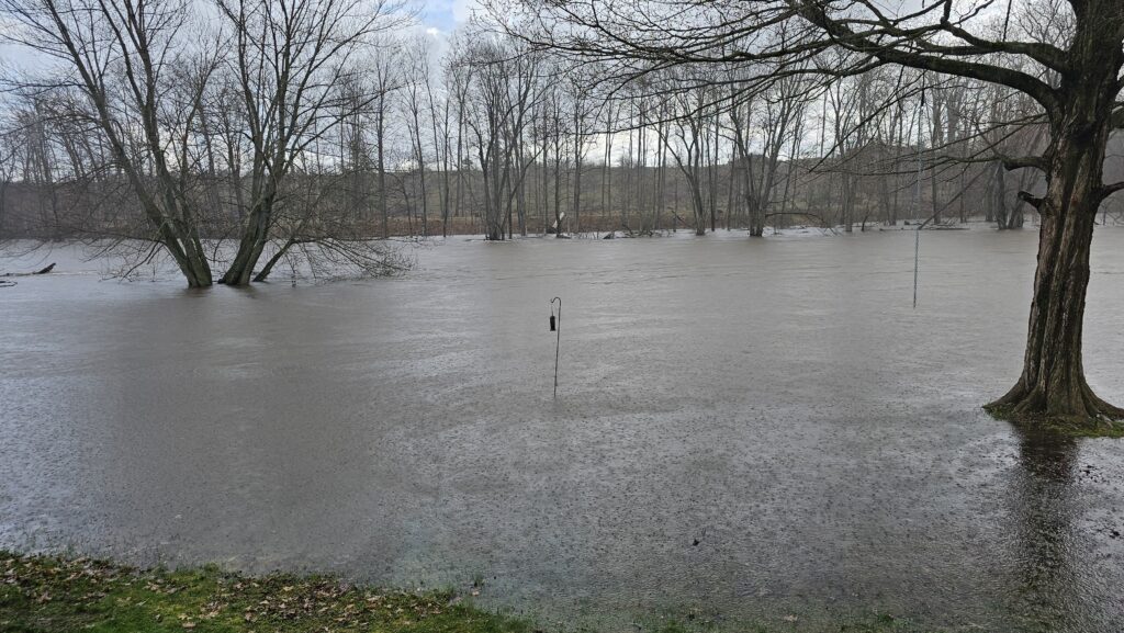
He added that, along with possible property damage, the flooding has taken a significant emotional toll.
“Watching your backyard be consumed by the river is very, very anxiety-provoking,” Takitaki said. “Not knowing if it’s going to cause major damage or how much of your yard you might lose to erosion was not at all a good time.”
The prolonged rainfall has led to widespread and ongoing flood issues across Michigan. Rivers, streams and drainage systems have been pushed to or beyond capacity, with some waterways reaching record highs.
Takitaki noted how, using data from the National Oceanic and Atmospheric Administration station in Evart and the surge of water in his yard, he was able to understand the severity of conditions locally.
“This was a record high,” Takitaki said. “We used the measurements and observations from the NOAA stations in Evart to keep track, and they exceeded their all-time record of 16 feet. The new record is 16.2 feet.”
Statewide regions are seeing repeated storm systems that rain down on already saturated ground. With soil unable to absorb this excess moisture, much of the rainfall has turned directly into runoff, quickly feeding rivers and lakes, worsening flood conditions.
With major storms appearing across most of the state, this wet season has seen precipitation levels well above average.
Geography Professor at Ferris State, Dr. Jennifer Johnson, spoke about how these conditions are affecting most of Michigan.
“Much of Michigan has had above-average snowfall and rain so far in 2026, particularly northern Michigan and the Upper Peninsula,” Johnson said. “Many locations are 200-300% above normal. March and April have been the wettest on record for quite a few cities.”
The amount of precipitation is so great that it isn’t just flooding homes and raising rivers, but directly impacting the Great Lakes.
“To put it in concrete numbers, Lakes Michigan and Huron have risen ten inches in the last month. That’s 8 trillion gallons of water, with snow still melting and rivers still high and carrying yet more towards them,” Johnson said.
Extreme rain and flooding are only some parts of severe weather affecting much of Michigan. Johnson also explained how we have experienced above-average tornado numbers for this early in the season.
“This year has been an excessively active one so far, with a preliminary count of 280 tornadoes from January to March, 80% above average and the eighth-highest count on record for that time period,” Johnson said.
Michigan has already suppressed the state’s annual average of 14 tornadoes, hitting 20 before peak season has arrived. Johnson also explained how this spike in tornadoes reflects nationally and how this trend might increase locally.
“Nationally, our long-term annual average is about 1200 tornadoes a year. In 2025, we had 1,559, in 2024 there were 1,791, and in 2023 there were 1,321,” Johnson said. “There is considerable evidence that Tornado Alley has been shifting east, and more tornadoes have been happening in the Midwest over the last several decades.”
As severe weather conditions increase its important to stay alert, monitor weather updates, and be prepared for extreme conditions.
For many residents across Michigan, the past few weeks have been a reminder of how quickly conditions can escalate and the importance of staying informed and prepared as the season continues.